

Date walked: 19th August 2017
Distance: around 9 miles
Map used: OS Explorer OL 14 – Wye Valley and Forest of Dean
Guide used: Offa’s Dyke Path by Mike Dunn. Published by Cicerone in 2016
************
A month after my aborted attempt to reach Monmouth, and having bobbed up and down on one leg hundreds of times much to Anne’s amusement, my calf and I were fit to resume. I had left off at Bigsweir Bridge, so this is where I started.

The Wye was looking very calm
The path climbs up the hill for a few hundred yards, passing a plethora of road signs, including a “Welcome to Gloucestershire”. For the geographically illiterate, we are on the Wales/England border here and the path does a certain amount of zig-zagging between the two countries; thankfully there are no border controls.

This reminds me of one of those pics you get shown on the Safety Awareness courses one takes when one has driven over the speed limit.
It was a warm day, so I was glad to turn into the deeply shaded Bigsweir Wood.

Some of the semi-mature beeches had evidence of visitors past; I like this fairly harmless graffiti – we have some on some of the trees in our own little wood.

The path was wide and even and climbed gently up the nicely named Creeping Hill…..

…. before emerging at a pointless stile and some grazing land.

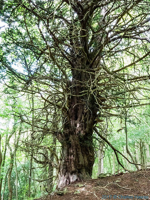
For the next mile or so I kept the wood on my left and then entered the Highbury Wood National Nature Reserve. Most of the nature was hiding, but I admired once again some ancient, struggling Yews.

On the far side of the wood, by Highbury Farm, an open field descending steeply to Redbook gave me a fine view of the old railway bridge crossing the Wye. I took my walking poles off my pack to ease my way down to the village.

I have driven through Redbook countless times. It has a cheery village shop that I have never been in…

… and two pubs. One of them, The Boat, is just over that railway bridge. Technically in Penalt, a non-village at the top of the hill, it is without doubt my favourite pub in Monmouthshire, serving beers straight off the barrel, good bar food and has no TV or piped music (though there is live music some nights if that takes your fancy). If I had been with a companion we would certainly have made the small detour.

Redbrook was historically an important industrial centre with mills, ironworks, tinplate works and copper works. The oldest site is the King’s Mill, which was a corn mill first recorded in 1434 and which remained in use until 1925. It’s amazing what comes and goes isn’t it?

From Redbrook, the path takes the road for half a mile, climbing up the hill towards Newland, before turning off and passing Duffield’s Farm. Just to confuse matters, it seems that Duffield’s farm, is, in fact, Jamie’s farm. They offer, amongst other things “Farming and Family Therapy”.

And they seem to have some sheep.

We, like sheep. I wonder if Ken Dodd ever tried to get a laugh from this.
From here, the path takes a farm track called Duffield’s Lane (Jamie’s Lane to be?)..

…. skirts the edge of Harpen’s Grove….

…. and then is fenced in between a wood and a private property as it approaches the Kymin.

I wasn’t sure what to make of a horse (donkey?) in the field that appeared to be being subject to comprehensive sensory deprivation, but I am sure that there’s a sensible explanation.

Go on, tell me what this is about?
The Kymin is a hill about 800 feet above the town of Monmouth. It boasts two of the county’s more unusual buildings.
The Round House was built at the end of the C18th by members of the Monmouth Picnic Club or Kymin Club, a group of Monmouth’s gentlemen, led by one Philip Meakins Hardwick who would “dine together, and spend the day in a social and friendly manner”. I suspect that they were up to no good.

Next to it is the Naval Temple.

This was constructed by the Kymin Club in 1800 to commemorate the second anniversary (why the second I don’t know) of the British naval victory at the Battle of the Nile in 1798 and in recognition of sixteen of the British Royal Navy’s Admirals who had delivered significant victories in other major sea battles of the age around the globe to that date.

Now you might feel that the role of the Admirals viz a viz your sailors doing the fighting is somewhat over-stated, but such is the nature of history. Who am I to judge?
At any rate, Princess Margaret had a hand in reconstructing it in 1987.

Whatever the merits of the buildings, it is a nice place to pause and take in the view.

The path drops down to Monmouth from here, taking a steep and narrow path through Garth Wood….

…. before opening out at the Kymin Road.
I thought it quite fun that there is a map of all the properties in the vicinity, complete with QR code.

Less jolly, was a serious warning to dog owners.

In a field by the road I passed a bunch of sheep who were demonstrating what Cwtch means.

If you asked me I would have said it was a bit warm for a Cwtch.
I also passed a small orchard of trained apples….

… which I determined required closer inspection.

Quite so
At the bottom of May Hill, is Monmouth’s Lidl (just in case you wanted to know here you might pick up supplies).

The path now crosses the Wye…

…. and goes through the centre of town, where there is no shortage of places to get refreshment.
Me, I picked up a nice bottle from the excellent Fingel Rock Wine Merchant, and a couple of cheeses from the equally excellent little cheese shop just down the road which sadly I can’t remember the name of and which Google has failed to find for me, before making my way to the bus station. An excellent walk – and, thankfully, a pain-free one.


Morning, Charles. Interesting to see the ‘high’ route between Brockwier and Monmouth. In heavy rain, we kept to the river bank into Monmouth. I think your sensory deprived pony is having the sense of flies in its eyes and ears deprived. And a coat for warmth. Also, she simply hates to be recognised. Glad the leg behaved. D p.s. I now expect a photo of each and every Lidl you walk past.
Yes, Bridget reckoned flies, too, but this was August so it would hardly need a coat for warmth. I suspect that there must be some additional psychological issue at play and extreme shyness seems one possibility. Is there a named syndrome, I wonder, for not wanting to be recognised? Perhaps it is facially disfigured? I doubt that there will be too many more Lidls en route but am happy to comply.
One of your best and nicely local. See what joys there are here besides our garden!
Thanks. love. There is no joy greater than our garden!
Glad the leg held up this time. Dave has an idea. On the Coast Path caravan parks were a recurring theme. Perhaps “Lidls of Offa’s Dyke” could do the necessary now? Around here, the locals have come up with a response to a plethora of road signs like that – they get covered with an old sheet painted with a birthday message.
Hmm. I think this may be over-doing the Lidl interest, though Dave is clearly very taken. Maybe both of you are being polite and want to ask “Why the pic of Lidl? To which I can only reply “I don’t know”. Perhaps it was the canoe. Thanks for the cultural information about your neck of the woods.
Lovely – but all I can now think about is cheese – where is that shop ? !
Get over it. You are hardly likely to be passing. (But its on the same side of the road as Irma Final about 50 yards further down towards the bridge.)
The cheese shop is called Marches. Its next to Raft. Your walking travelogue is very amusing, I laughed out loud at the sensory deprived pony.
Always nice to think of people reading these posts years later. And thanks for the comment.
Looks like a lovely walk.
(That donkey, by the way, put up that plaque about nothing going on…. )
It was. That is a strange Donkey fantasy.
My guess would be that the pony is often plagued by flies. The coveralls are to keep them off, especially round the ears and eyes.
Thus the sensory deprivation is is of something that would be akin to being ‘midged’ in Scotland!
Plausible! Thanks!
I do love nature and your photos are all so stunning, the views, the trees and everything it was perfect. I was just bothered with the Donkey, how could they dress him like that. Did he even see? I am sure that donkey doesnt like how they dress him up.